A workflow is a good start if you want to build an application. However, sometimes it’s still necessary to add control elements. In this section, you’ll learn to add buttons and to write server side code to make your application even more powerful.
CYPEX lets you write PostgreSQL functions directly in the admin panel. Those functions are served by PostgREST, the same component that serves your queries: a function in the exposed schema becomes an RPC endpoint at /rpc/<function_name>, called with POST and executed as the role in the caller’s JWT. Data and logic therefore travel the same path and obey the same PostgreSQL permissions.
CYPEX works directly on PostGIS: spatial columns keep their PostgreSQL
geometry or geography type, and applications read them through
generated queries and map elements. Generated default queries pass the raw
geometry through unchanged, which a browser cannot render — convert it
yourself with ST_AsGeoJSON in a custom query. Two Application Designer
elements consume the result: Leaflet Map GeoJSON displays it read-only,
and Leaflet Map GeoJSON Input adds drawing and editing of markers,
lines, rectangles, polygons, and text annotations. Both render over one
configurable base tile layer (OpenStreetMap by default).
CYBERTEC provides a set of extensions which can be used to simplify the process of building applications. In this section you’ll learn which extensions exist and what they are capable of doing.
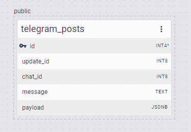
Extension: telegram_posts
Purpose:
Store telegram posts
ER model:
Description:
The extension consists of just one table. The content of the message is stored in the “payload” column.